|
| Canada: Climatically a little worse for wear. |
[Note: Click the Pics to enlarge]
Climate disruption has come with a vengence to Canada. Cathie and I spent our two week honeymoon in four of Alberta's National Parks and one nearby provincial park.
We experienced the beauty of Canada and the impacts of dry forest conditions that spawned over
57 major fires in British Columbia. B.C. is dealing with back-to-back record wildfire seasons with more than 945,000 hectares (~ 2.4 million acres) burned. In the U.S. 68 large wildland fires have burning more than 684,000 acres on National Forest System lands. As of August this year 4,256 wildland fires have burned 1,176,458 acres of NFS land.
 |
The view from the Banff Gondola
ride top on a moderate smoke day. |
We drove through some of the fire impacted area in
Kootenay National Park that caused nearly all of the forest roads and sites to be closed.
Most of our time in Alberta there were serious health advisory warnings due to the smoke conditions. This contributed to less than spectacular photography of distant views, but the trip was still great with Cathie sharing the beauty of the Canadian Rockies in August.
Our start and end of the trip were in Calgary, Alberta. After two nights in Calgary we drove to Banff for four nights, then five in Jasper, a night in Lake Louise and the last night again in Calgary before flying home.
 |
| Historic Cosmic Ray Station |
On top of Sulphur Mountain outside Banff is the historic
Cosmic Ray Monitoring Station.
Banff is in the
Bow River valley where the melt water flows from the Athabasca
Glacier and others. The glacial dust suspended in the waters create varying shades of green and blue. Jasper has a couple of canoe and raft rental companies offering variable length floats down the river that leads to Hudson Bay.
Just outside the town is the
Cave and Basin Site.
Banff National Park is Canada's oldest national park and was established in 1885. The impetus for the park was the preservation of naturally flowing sulfuric hot springs that private entrepreneurs sought exclusive use.
 |
| Bow River Watershed |
|
 |
| Bow River kayak rentals outside our motel room. |
|
|
|---|
| |
| The Government of Canada saw Banff as the perfect location for creating a national park system. |
|
The hot springs and 16 square kilometres surrounding the Cave and Basin site were deemed off-limits for sale or settlement. Soon the park boundaries were widened. A town, a bridge over the Bow River and a hotel were constructed so the public could access the Cave and Basin. Not too far from the cave is this hot spring with algae thriving in the very hot water. The hot springs cool as they drain into a local marsh with a boardwalked wildlife viewing area.
|
 |
| Cathie in her purple hiking uniform |
Hiking trails abound in the vicinity. A hike up to the Hoodoos along the Bow River reveals the wildness of the park immediately outside the city of Banff.

Along the Bow Valley Parkway is a monument commemorating the memories of the World War I Castle Internment Camp built in 1915 at the base of Castle Mountain.
The camp held immigrant prisoners Ukrain, Austria, and Hungary. The Jasper Historical Society has a special exhibit regarding the experiences of the prisoners.
|
 |
| Internment Camp Roadside Monument |
| |
|---|
 |
| A Black Bear along the Icefields Parkway |
 |
| Big Horn Sheep along Highway 16 |
|
 |
| Rocky Mountain Goats at the same location in the afternoon |
|
While in Jasper we took a side trip east out of the park to the town of Hinton and visited a provincial park and visited a city park in Hinton containing a raised boardwalk through a huge beaver pond.
On the road to the beautiful Emerald Lake near Lake Louise is the so-called
Natural Bridge created by the undercutting force of glacial waters of the
Kicking Horse River. In the area can also be found the Spiral Train Tunnels, Wapta Falls, Takakkaw Falls and other points of interest.
 |
 |
| Natural Bridge |
|
 |
| Takakkaw Falls |
|
|---|
We were able to see about a dozen glaciers within the four national parks we visited. Peyto Glacier, named for
Bill Peyto, an early trail guide and trapper in the Banff area, and the lake were most picturesque from on high. The much higher glacier along the continental divide created a delta prior to the emerald blue lake. These wonders are the source of the Mistaya River.
Mistaya in the Cree language translates to grizzly bear.
One of the most visited locations in Alberta is
Maligne Lake. This fact stems from a famous photograph of Spirit Island used by the Canadian Pacific Railway at the turn of the century to promote recreational tourism in the region. Reachable best by chartered motorboat or canoe/kayak, the island still does not disappoint visitors.
 |
| Spirit Island on Maligne Lake |
|
 |
| Maligne Lake Charter Cruise Boats. |
|
Swiss mountaineers lived at Lake Louise where they originally led wealthy visitors to the nearby peaks and glaciers. Once the railway came near, tourism from the general population soared.
 |
| Fairmont Chateau Lake Louise and memorial to mountain guides |
|
 |
| Flowers abound the Lake Louise lakeshore |
|
|---|
 |
| A Cow Moose at Moose Lake 1/2 mile from Lake Louise |
One of the most interesting sites to me near Jasper was the
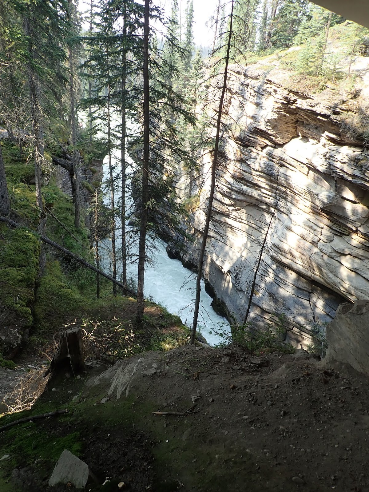
Maligne Canyon. There are six pedestrian bridges across that are up to 50 meters deep in the very narrow canyon. They bridges provide great views of the force of nature cutting through the rock.
 |
| Maligne Canyon 1 |
|
 |
| Maligne Canyon 2 |
|
 |
| Maligne Canyon 3 |
|
|---|
 |
| Maligne Canyon 4 (Bridge #2) |
Rated as one of the 25 best waterfalls in Canada is Athabasca Falls ("Athabasca translates from Cree to 'grass or reeds here and there'. "As the upper Athabasca River flows from the Columbia Icefield through the Jasper National Park in Alberta, it chips away at the rock, forming a canyon until it drops 80 feet over a thin layer of hard quartzite through soft limestone, carving first the short gorge and many potholes as well. What makes Athabasca Falls so picturesque is not the height but the force the huge volume of water creates as it drops into the gorge. The water formed many natural viewing platforms and trails that are still being chipped away, one millimeter every year. There are stairs that lead to the base of the falls that will allow you to closely view small plants, mosses, and lichens that managed to cling to the rock. You can cross the concrete bridge to the other side of the gorge. The falls are popular among white-water rafters, who start at the falls’ base and head all the way to Jasper."
 |
| Athabasca Falls 1 |
|
 |
| Athabasca Falls 2 |
|
 |
| Athabasca Falls 3 |
|
|---|
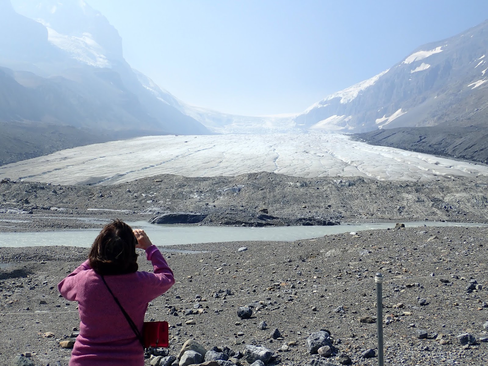
It is hard to pick out my favorite location from this trip to Alberta. That distinction probably falls upon the Athabasca Glacier that flows over Athabasca Falls. It the heads across the continent and empties into the Arctic Ocean. I've longed for decades to stand on or adjacent to such a glacier. This one is disappearing fast.
 |
| Athabasca Glacier Retreating Quickly |
|
 |
| Cathie watching people far up on the Athabasca Glacier |
|
|
|---|
There was far more beauty that we experienced on this trip besides these views. We leave those mental images to you to find on your own adventures in life. Get out there!
#