Monday, October 12, 2015

Dripping Springs Natural Area & The Organ Mountains

Organ Mountains - Desert Peaks National Monument

View Along the Trail To Dripping Springs
I was in Las Cruces, NM during October, 2015 and my forthcoming adventures will be further explorations of the Rio Grande Rift and its impact on southern New Mexico.

Chihuahuan Desert
Ten miles east of Las Cruces sits Dripping Springs Natural Area which is now part of the Organ Mountains-Desert Peaks National Monument, another beautiful site managed by the Bureau of Land Management.

The Organ Mountains are a series of steep, rocky needles that jut dramatically above the Chihuahuan Desert floor to an elevation of 9,000 feet. Sitting astride the Rio Grande Rift, they are the result of tectonic plate movement along this long fault line in the desert southwest.

There is primitive camping on nearby BLM land and 57 family campsites and two group sites in the Aguirre Spring Campground located on the east side of the Organ Mountains. It overlooks the Tularosa Basin and White Sands National Monument which I will be visiting next month.

There is a visitor center, twelve picnic sites, and more than 50 miles of hiking trails in the area. Hiking in the morning hours is recommended for the western slopes so that you can stay in the shadow of the Organ Mountain peaks.

Western View Along The Dripping Springs Approach Trail
Cabin Construction
I hiked about four miles at Dripping Springs to see the remnants of the Dripping Springs Resort and Sanitorium built by Colonel Eugene Van Patten in the 1870s. Partially restored buildings show how medical treatments of the late 1800s often relied upon the notion of recuperating from illness in secluded locations surrounded by nature, with abundant sunshine, fresh air, natural springs,and dietetic regulation. For example, consider the Battle Creek (Kellogg's cereal fame) Sanitorium.

I would have likely enjoyed living in these cabins and taking daily walks along the secluded mountain trails. Still visible are the livery stable, water retention reservoir, and a couple of the guest cabins perched high on the hillsides.

Nature abounds in the narrow Organ Mountains canyons. The local native plant society has helped preserve or replant almost 200 different trees, shrubs, grasses, ferns, cacti, and herbs in the canyon and at the visitor center.

Remnants of Resort / Sanitorium
High View of the Resort / Sanitorium
through the Dripping Springs
Stream Canyon Walls
Yucca Plant Stem


Tree Cholla (Candelabra Cactus)


Saturday, October 10, 2015

On the Road Building Homes With Habitat For Humanity

Weeks 1 & 2
Habitat For Humanity's Care-A-Vanner Program Banner Image

I shifted gears this week from playing tourist in the nation's national parks to being a volunteer home builder for Habitat For Humanity. I'm on scene in Mesilla Valley (Las Cruces, NM) for a month helping build two homes. I've joined a group of nine other, experienced Care-A-Vanners and a few locals that are partnered with two future homeowner families to build their first home.

Each week I'll update progress with pictures and notes below about the Care-A-Vanner experience.

Week One

This first week we made quite a bit of progress. Before the official build began I helped the homeowners clean-up the site to make it a safe work zone. The water/sewer lines had already been installed, the slabs had been poured, and the construction trailers with materials and porta-potty were all pre-positioned. This was our starting point.

Day Zero: Two Building Sites Prepped for the the
Care-A-Vanners to Start Building
 "Houses built on owner’s land take about 8 months if built by a contractor and more than 11 months if they are owner-built (i.e., where the owner of the land serves as a general contractor). Single-family homes built for rent take, on average, between 8 and 9 months from permits to completion." ~ NAHB
Discounting the time to get the site to this pristine condition, imagine the pace we are setting for ourselves to have these homes ready in less than two months by a dozen volunteers.

Day One: Exterior walls built


Day Two: 

Exterior walls sheathed, windows cut,
and wall top plates ready for
the next day's roof truss install.


Day Three: 

Walls plumbed, porches built,and trusses installed.


Day Four:

Rafter tails trimmed and fascia boards readied.

Day Five: 

Roof rafters stabilized and all secured with hurricane clips

Day Five Continued:

Interior walls all built and readied for next week's 
roof sheathing.


The weather has been cooperating with temperatures in the 80's. More of the same is expected next week, but by the end of October temperatures will drop into the 70's and 60's. No matter the temperature, Care-A-Vanners keep building.

Week Two

After a well deserved three day weekend (normally only two days) we got back to work on our crew's first two houses on this street.

Day Six: 

All the exterior sheathing, roof decking, and some of the 
roof's drip edging was installed. On the inside of the 
building assorted framing details were completed in 
anticipation of contractors arriving the next day to begin 
their work.


Day Seven:

The windows arrived from the supplier and they
installed carefully to prevent air infiltration.
Soffits previously painted and continuous soffit vents
were installed and cardboard baffles were placed to
allow the free flow of air from these vents above the
insulation that will later be installed in the ceiling.


Day Eight: 

In many builds specialty crafts such as electrical and 
heating, ventilating and air-conditioning (HVAC) work is 
contracted out to private companies or it is donated by 
area firms. Today the private HVAC crew began the 
"rough-in" of the ductwork and piping.

The role of private contractors varies at each Habitat
build site. At this affiliate, the following crafts are contracted:
Concrete, plumbing, HVAC, electrical, insulation and the
finishing of drywall joints. Code requirements and finances
usually dictate how much work is done by outside contractors.


The HVAC and plumbing contractors completed 
their rough installation of all the ductwork, air registers  
and grills, plus air conditioner plumbing and  electrical 
control cabling, plumbing vent pipes, and exhaust vents.


The concrete slab has drawn on it the locations of all the
walls, studs, doors and windows. These dimensions were all 
transferred to the preservative treated wooden floor plates and 
top wall plates.With these templates workers are then able to 
build assemble all the parts and bolt the wall to the floor.

Day Nine

Roof shingling was started on the left house after the drip
edge was 
installed and most of the volunteers began to erect
house #2's walls.


In this particular two week build this was last day for 
Care-A-Vanners who need to return to their other lives
or travel to a different Habitat build. 

Tomorrow we will be down by six Care-A-Vanners, 
but two replacements will step-up to carry on the work
starting next Tuesday. That means we won't be quite as
productive in the next two weeks, but according to our
site supervisor we are about four days ahead of schedule


Day Ten

On Saturdays at many builds it is common to have
organized groups of volunteers from community

businesses or organizations to come "learn by doing"

in building whatever is needed that day. 


We had a dozen volunteers from First New Mexico Bank 

supplement our Care-A-Vanners this week. They helped
build walls, 
apply sheathing to the now fully erected exterior
walls of 
house #2, and install house #1's roofing underlayment
and 
shingles to get the house dry for interior construction

projects. Care-A-Vanners built the front and back porch 

columns and support beams.

Next week we will complete the walls, roof, and windows
of house #2 and move on to drywalling


If you have any questions about the role Care-A-Vanners 
play in Habitat projects or anything about the construction
process, please ask.

Pollution Pays Off

Source: Durango Herald
Travelling by RV through the Rocky Mountains is a visual treat. Awesome vistas, towering peaks, wildlife unique to the intermountain west, abundant springs, waterfalls, raging rivers, and a rich history of stalwart pioneers, mountain men, and miners all looking for the motherlode.

Hidden from view are toxic threats almost too numerous to count and comprehend. Two months ago I wrote about the Gold King "mine spill" into the Animas River near Silverton, Colorado. The river no longer runs with the dirty yellow color, but the toxic threat remains. I drove to the area last month to get a better sense of the disaster's impact. On the surface things looked normal for a tourist mecca: lots of traffic, no apparent business closings except a temporary shutdown of the river rafting companies. The community seemingly dodged the silver bullet. I spoke to an RV campground owner about the impact and was told that the day after the spill, he received eighteen reservation cancellations, but that business was mostly back to normal for now.
“The West has 550,000 abandoned and inactive mines; 10,000 miles of degraded rivers and streams; hundreds of polluted lakes and reservoirs; and, more than 50 Superfund sites,” according to the Center for Environmental Equity.
There are at least five sites with pollution problems worse problem than the Animas River.

The pollution remediation to the Gold King mine "accident" is well underway at a cost to taxpayers of about $1,000,000 per year. This is just a temporary fix to the widespread problem of abandoned hard rock mine acid drainage. It would likely take $50 BILLION to address all the existing mine leaks.

Knowing now the toxic threats throughout the West it's hard to look at the Rocky Mountains with the same sense of awe that I had as a child first travelling to the mountains. Me: innocence lost and rage increased.

What can be done about the situation? Well Congress could fix the problem of new sources of pollution by eliminating the General Mining Law of 1872 that enables any person or corporation to stake a claim and start polluting. See how easy it is to become a permitted polluter!

Republicans have long fought reform efforts to protect the environment, and specifically the General Mining Law of 1872. With the current unmanageable, Republican dominated house of Representatives, little hope exists for progress. The mining lobby spent almost $23 million dollars last year influencing industry favorable legislation.

Sunday, October 4, 2015

Vestiges of Visitors and Volcanoes

Petroglyph National Monument

Rinconada Canyon Plain 
Having arrived in Albuquerque four days before the annual International Balloon Festival, I wanted to visit the many attractions of this community in the desert before the crowds arrived.

I took the first day to do laundry, run errands, and just rest, but on the second day I made a beeline for Petroglyph National Monument. This landmark could be considered an urban national park because it forms the southern border of the city and is co-managed by the City of Albuquerque. It is one of fourteen NPS sites in New Mexico and is part of the complex maze of early North American settlements of which there are around sixty in the Southwest that are protected by the National Park Service. Interactive Map and List

The city has a lot to offer visitors besides the balloon festival: cultural centers, museums, arts, a big foodie scene and numerous micro-brew pubs, a zoo, aquarium and botanic garden, and lots of outdoor activities. Here's a sampling:
And if you are really into the whole Route 66 Tour culture, Albuquerque is a great stopping point for retro history exploration.

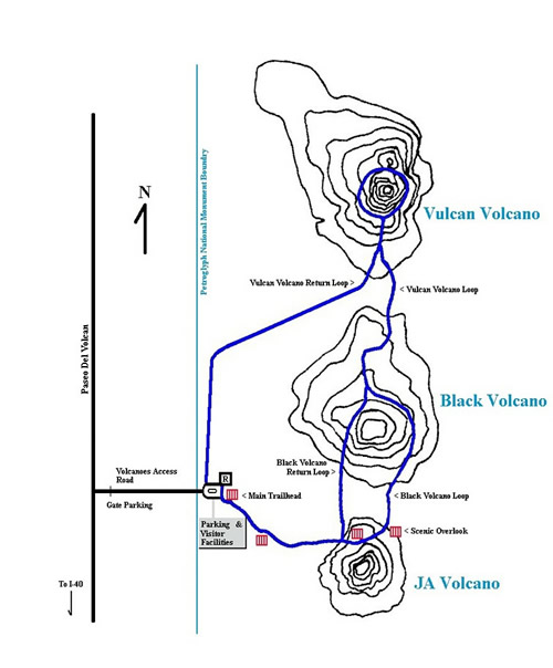
Besides the professionally staffed with very cheerful interpreters at the Petroglyph National Monument visitor center, the monument has two canyons for hiking to see petroglyphs and one trail through a geologically interesting, extinct volcano range.

Rinconada Canyon

I enjoyed the hidden mystery of hiking this 2.2 mile flat trail to see petroglyphs galore. The return route is petroglyph free, but if you like desert plant life there is much to see.


This not your typical petroglyph site. It's not a high canyon wall with images pecked and chiseled in soft, varnished sandstone, but rather very long pile of hard, igneous, basaltic rubble from a 200,000 year old volcano that flowed from a five-mile fissure and then fell from the escarpment when the soft sand beneath it eroded away its foundation.

The outgoing trail is studded with often hard to see basaltic petroglyphs because a cable barrier has been put in to help the plant life recover from visitor trail proliferation and reduce cultural vandalism. You can't and shouldn't touch the petroglyphs. Most of the glyphs are towards the end of the 1.1 mile trail so stick it out until the end to see some of the best to be seen. Do carry plenty of water and best viewing is earlier or later in the day.

Sorry, but my photos photos below were all taken in early afternoon when visual contrast is lowest. The petroglyphs are but a sampling of a images created by three groups of people: 1) ancestral puebloans that settled throughout the Southwest, 2) early Spanish explorers, and 3) Atrisco Land Grant holders (principally sheep herders in the 1600s) who added their modern images to those of the puebloans. What did they add? Christian crosses, livestock brands, and the self-promotion images predating the better known:Kilroy Was Here moniker. Most of the petroglyphs are between 400 and 700 years old. Some may be 2,000 to 3,000 years old!


Interpretation of Petroglyphs is both an art and science. While some is known about the meanings of the images, there is a lot still not known. Is it simply art or is it writing?  For example, consider the Spiral Petroglyph that is found in every ancient culture throughout the world.
"The spiral is to be traversed clockwise going from the outside top of the spiral and following it clockwise to the center of the spiral. It means "go up" and can be thought of as looking down on a hill and seeing a spiral path to the top. A similar spiral where a clockwise traversal would go from the center to the outside would mean "go down" (always go clockwise)." 
Petroglyph National Monument has over 1,200 images for anyone to try and correctly interpret.

Here is what I recommend viewing at this monument.

Albuquerque's Volcano Trails 

There are three volcanic cinder cones on the western side of the monument called the Three Sisters. Their unexpected names are Ja, Vulcan, and Black. They were created similar to the Hawaiian Islands. At each spot on the planet tectonic plates forced lava from the depths of the earth. They were formed by sequential eruptions along a fissure as the tectonic plates moved northward. Since the Hawaiian rift is still very active, new islands will recur in the future.

In this part of New Mexico the three remnant cinder cones are part of the barely active Rio Grande Rift Valley. (It moves only a couple millimeters a year).
It is only one of a few active rifts on the planet. The Three Sisters were formed at the same time as the Hawaiian Islands..


Today, all that remains after millenniums of erosion, ranching, rock mining, military bombing, illegal dumping, and off-road vehicle use are the violated remnants of three powerful symbols.

Some Native Americans consider the sites sacred and that climbing the cones is a sacrilege. Hispanics see the entire west mesa as a living reminder of their cultural heritage and a special site for their religious ceremonies.
Approach to JA Volcano
Vulcan Volcano
View North From Black Volcano Summit to Vulcan Volcano

View South From Black Volcano Summit to JA Volcano
Stinkbug Standoff With Shotgun Shell
Desert Beetle

Mesa Verde National Park

Ancestral Puebloans of the Canyons of the Chapin and Wetherill Mesas

Spruce Tree House Cliff Dwelling
High on my 2015 travel bucket list has been a visit to Mesa Verde National Park, a UNESCO World Heritage Site, near Cortez, Colorado. My previous day's visit to nearby Hovenweep National Monument helped set the stage for the treasures that Mesa Verde presents. The UNESCO website succinctly describes the merits of the park:
Square Tower House
The Mesa Verde landscape is a remarkably well-preserved prehistoric settlement landscape of the Ancestral Puebloan culture, which lasted for almost nine hundred years from c. 450 to 1300. This plateau in southwest Colorado, which sits at an altitude of more than 2,600 meters (8,530 Ft), contains a great concentration of spectacular Pueblo Indian dwellings, including the well-known cliff dwellings. This rich landscape provides a remarkable archaeological laboratory for enhancing our understanding of the Ancestral Puebloan people.
Some 600 cliff dwellings built of sandstone and mud mortar have been recorded within Mesa Verde National Park – including the famous multi-storey Cliff Palace, Balcony House, and Square Tower House – and an additional 4,300 archaeological sites have been discovered. The cliff dwelling sites range in size from small storage structures to large villages of 50 to 200 rooms. Many other archaeological sites, such as pit-house settlements and masonry-walled villages of varying size and complexity, are distributed over the mesas. Non-habitation sites include farming terraces and check dams, field houses, reservoirs and ditches, shrines and ceremonial features, as well as rock art. Mesa Verde represents a significant and living link between the Puebloan Peoples’ past and their present way of life."
The Mesa Verde Visitor Center, Chapin Mesa Archeological Museum, and signage at each site comprehensively outlines the evolution stages of the Mesa Verde community culture and physical infrastructure during the following five periods of history:
Sunset House
The park educational displays allow the visitor to easily observe how building construction techniques of individual homes and ceremonial structures changed over time in response to:
  • Environmental challenges such as drought and fire
  • Technological innovation in tools and construction techniques
  • External threats from enemies, and
  • Natural threats such as depleted resources and population shifts
I could have spent many days exploring all the features of this park. The main archaeological features are are located at the far end of the entrance road that climbs for almost 20 miles.

RV campgrounds are located near the park entrance and in nearby towns.


Mesa Verde's Semi-buried Wood and Adobe Constructions

Early Pit House Perimeter
Pit House w/ Far Fire Chamber
and Smoke Deflector in Openway
Family and Ceremonial Kiva

Above Ground Pueblo Construction

Sun Point Pueblo Remnant.
Upper Stones Possibly Removed for Building Cliff Dwellings

Sun Point Pueblo: Left Passage
Sun Point Pueblo: Right Passage


Mesa Verde's Cliff Dwellings

You need to visit this park!