Petroglyph National Monument
 |
| Rinconada Canyon Plain |
I took the first day to do laundry, run errands, and just rest, but on the second day I made a beeline for Petroglyph National Monument. This landmark could be considered an urban national park because it forms the southern border of the city and is co-managed by the City of Albuquerque. It is one of fourteen NPS sites in New Mexico and is part of the complex maze of early North American settlements of which there are around sixty in the Southwest that are protected by the National Park Service. Interactive Map and List
The city has a lot to offer visitors besides the balloon festival: cultural centers, museums, arts, a big foodie scene and numerous micro-brew pubs, a zoo, aquarium and botanic garden, and lots of outdoor activities. Here's a sampling:
- Anderson-Abruzzo International Balloon Museum
- National Museum of Nuclear Science & History
- New Mexico Museum of Natural History & Science
- Sandia Peak and Aerial Tram
- New Mexico Museum of Space History
Rinconada Canyon
I enjoyed the hidden mystery of hiking this 2.2 mile flat trail to see petroglyphs galore. The return route is petroglyph free, but if you like desert plant life there is much to see. |
 |
 |
This not your typical petroglyph site. It's not a high canyon wall with images pecked and chiseled in soft, varnished sandstone, but rather very long pile of hard, igneous, basaltic rubble from a 200,000 year old volcano that flowed from a five-mile fissure and then fell from the escarpment when the soft sand beneath it eroded away its foundation.
The outgoing trail is studded with often hard to see basaltic petroglyphs because a cable barrier has been put in to help the plant life recover from visitor trail proliferation and reduce cultural vandalism. You can't and shouldn't touch the petroglyphs. Most of the glyphs are towards the end of the 1.1 mile trail so stick it out until the end to see some of the best to be seen. Do carry plenty of water and best viewing is earlier or later in the day.
Sorry, but my photos photos below were all taken in early afternoon when visual contrast is lowest. The petroglyphs are but a sampling of a images created by three groups of people: 1) ancestral puebloans that settled throughout the Southwest, 2) early Spanish explorers, and 3) Atrisco Land Grant holders (principally sheep herders in the 1600s) who added their modern images to those of the puebloans. What did they add? Christian crosses, livestock brands, and the self-promotion images predating the better known:Kilroy Was Here moniker. Most of the petroglyphs are between 400 and 700 years old. Some may be 2,000 to 3,000 years old!
 |
 |
 |
 |
Interpretation of Petroglyphs is both an art and science. While some is known about the meanings of the images, there is a lot still not known. Is it simply art or is it writing? For example, consider the Spiral Petroglyph that is found in every ancient culture throughout the world.

"The spiral is to be traversed clockwise going from the outside top of the spiral and following it clockwise to the center of the spiral. It means "go up" and can be thought of as looking down on a hill and seeing a spiral path to the top. A similar spiral where a clockwise traversal would go from the center to the outside would mean "go down" (always go clockwise)."
Petroglyph National Monument has over 1,200 images for anyone to try and correctly interpret.
Here is what I recommend viewing at this monument.
Albuquerque's Volcano Trails
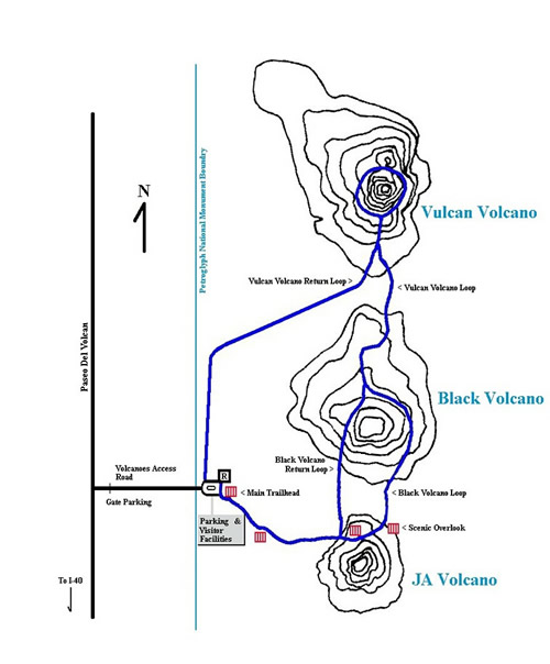
In this part of New Mexico the three remnant cinder cones are part of the barely active Rio Grande Rift Valley. (It moves only a couple millimeters a year).
It is only one of a few active rifts on the planet. The Three Sisters were formed at the same time as the Hawaiian Islands..

Today, all that remains after millenniums of erosion, ranching, rock mining, military bombing, illegal dumping, and off-road vehicle use are the violated remnants of three powerful symbols.
Some Native Americans consider the sites sacred and that climbing the cones is a sacrilege. Hispanics see the entire west mesa as a living reminder of their cultural heritage and a special site for their religious ceremonies.
|
|
|


|
|
|


No comments:
Post a Comment